Introduction to Geospatial Data Analysis with Python | SciPy 2018 Tutorial | Serge Rey
Video Not Working? Fix It Now
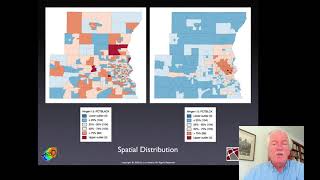
This tutorial is an introduction to geospatial data analysis in Python, with a focus on tabular vector data. It is the first part in a series of two tutorials; this part focuses on introducing the participants to the different libraries to work with geospatial data and will cover munging geo-data and exploring relations over space. This includes importing data in different formats (e.g. shapefile, GeoJSON), visualizing, combining and tidying them up for analysis, and will use libraries such as `pandas`, `geopandas`, `shapely`, `PySAL`, or `rasterio`. The second part will built upon this and focus on more more advanced geographic data science and statistical methods to gain insight from the data.
No previous experience with those geospatial python libraries is needed, but basic familiarity with geospatial data and concepts (shapefiles, vector vs raster data) and pandas will be helpful.
See tutorial materials here: https://scipy2018.scipy.org/ehome/299527/648136/
See the full SciPy 2018 playlist here: https://www.youtube.com/playlist?list=PLYx7XA2nY5Gd-tNhm79CNMe_qvi35PgUR
Comment